DLA2020 VIRTUAL CONFERENCE
Student Poster Exhibition
“Digital Landscape Architecture”
For the DLA2020 Virtual Conference June 3-4 2020, current students and recent graduates were invited to submit original design / artwork; the only requirement, other than size & format, was that all work must demonstrate / explore / exemplify “Digital Landscape Architecture”.
POST-CONFERENCE UPDATE: CONFERENCE PARTICIPANTS VOTED ON ‘BEST POSTER’ in 3 categories: (not necessarily mutually exclusive – one poster could be all 3)
- Most visually appealing
- Most interesting, challenging, or memorable
- Most imaginative use of DLA technologies, in content or representation
FIRST PRIZE — IN ALL THREE CATEGORIES: #22
SECOND PRIZE — IN ALL THREE CATEGORIES: #18
THIRD PRIZE — IN ALL THREE CATEGORIES: #29
DLA2020 POSTER SUBMISSIONS
ID
- 12 Park Suitability Index: developing a landscape metric for analyzing settlement patterns… — Luwei Wang
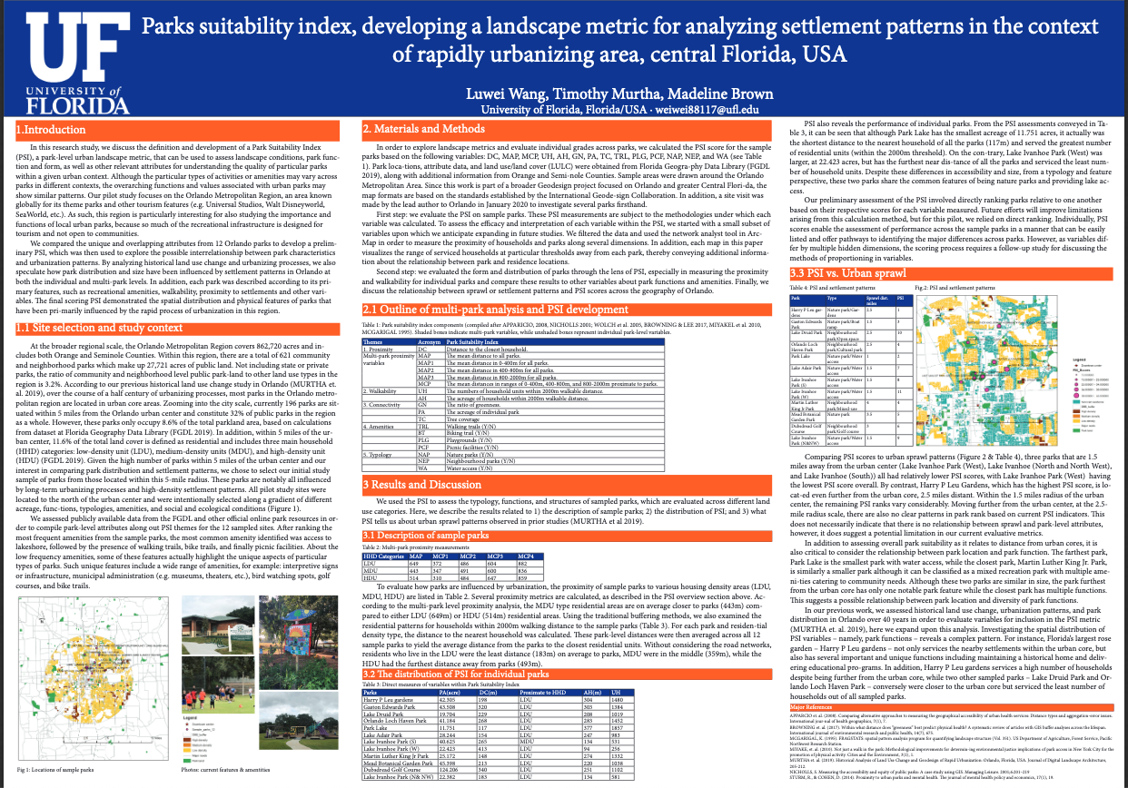
Abstract: ” Central Florida has experienced sustained and substantial urban land expansion over the last half-century. In Florida, urban expansion intersects natural and human systems. Investigating the relation-ship between landscape conditions and urbanization processes in Central Florida, therefore, requires a critical assessment of local natural and human conditions through time. In this paper, we examine the relationship between urbanization and landscape patterns through the lens of urban public parks. As a vital component of landscapes, parks reveal patterns and processes that influence landscape ecology in urban settlements (TURNER 1989). To better understand the multiple influences of natural and human factors on park design and planning, this paper introduces the idea of a park suitability index (PSI), which is targeted at quantifying the form, function and distribution of parks as they compare to settle-ment patterns. Critically, the PSI combines multiple measures into a single comparative metric for in-forming land use planning and landscape design for urban parks. Using a sample of 12 Orlando parks and a subset of variables, we develop the framework for a methodology that defines key parameters of the PSI for use in urban design and planning. Specifically, we evaluate the influence of urbanization patterns on park resource availability and diversity. In addition, we examine community-level functions of parks by considering the form and distribution of parks as compared to settlement patterns. These analyses provide the baseline for developing a more generalizable PSI for use in landscape planning both in Florida and elsewhere “

Abstract: ” This poster presents a landscape speculative project, which involves different phases and switches through different tools and media. It serves as a case to discuss landscape design and workflows. It is a discussion on subtle interactions between landscape conceptualisation, crafting and fabrication processes. Through a set of references and re-enchantment of universal turbulences, it argues for the simultaneity and complexity of materialistic manipulations and levels of control between crafting and fabrication.
Phase I. A process of making: Through initial project phase a variety of landscape ‘makings’ were completed. A number of those ‘makings’, optimised through various tests and triggered through changes in texture, ingredients and consistence, presented diverse landscape reparations.
Phase II. A process of modeling + fabricating: A limited number of structures were selected to create virtual models. Those formed the input for fabrication. Plaster, wax, plastic, seeds, leaves, stone, metal, charcoal and oil formations turned into mesh of points, vertices, surfaces, edges, and vectors to prepare a list of instructions for machinic operations.
This contribution to DLA 2020 conference focuses on subtle interactions between crafted and fabricated landscape samples. Within this context, ‘paradisiacal’ matter is sample abstracted from natural grounds. Fabricated sample is extracted from modelled grounds and built from matter of natural origin (corn, etc).Such materialistic manipulations may discuss eloquent arguments on synthetic vocabulary through different mediated processes. “
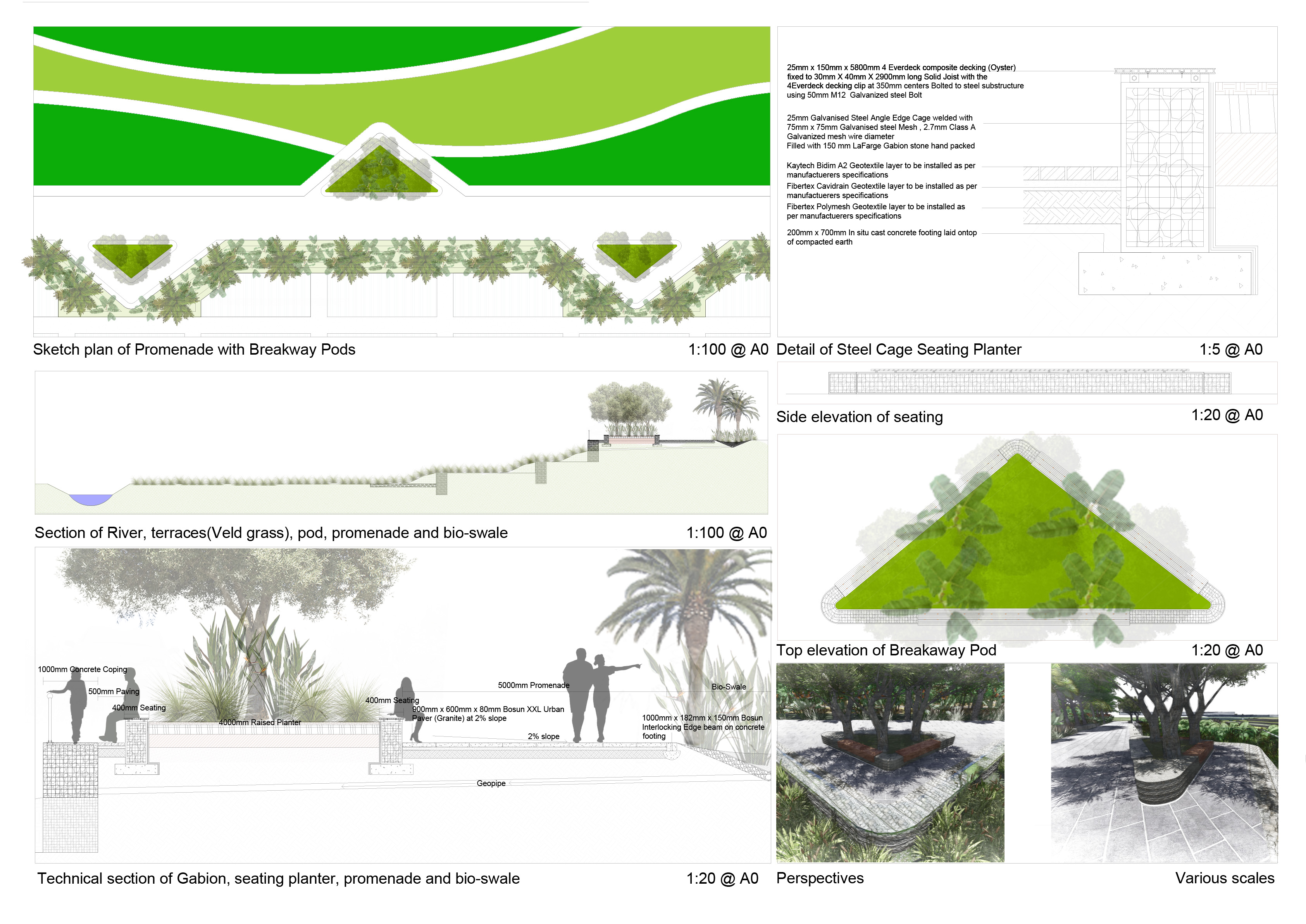
Abstract: ” How to create a river crossing landscape design that addresses ecological sensitivity, cultural inclusivity and societal needs such as economic upliftment, intergenerational education and skills development. ” “
Abstract: ” The central principle behind conserving river systems is to set aside a certain area of land to create representations of ecosystems that occur in the region to act as ecological or biodiverse depository. This is done to buffer against future modifications of the river systems in an effort to preserve the original biodiversity presence (Roux & Nel, 2013). There is a need for the conservation for the waterways of Pretoria to increase biodiversity and ecosystem service potential. The study site is in the Berea Park area, which are historic sportsgrounds that are now abandoned. The site sits adjacent to the Apies River within the 1:100 year flood line and can get completely flooded during such a flood event. The river was dechannelised and various flooding strategies where incorporated to mitigate and absorb the treat of a flood in the city.
Education plays an important role in conservation and developing the site. However, it has been shown that people have inherent biases to ignore the environment around them in favour of more active attention. This is known as plant blindness and is a major issue when trying to create awareness of ecological importance (Allen, 2003). The purpose of this dissertation is to test the viability of conserving regional river plant species in Pretoria through devising strategies to display plants in such a way as to counteract plant blindness. By placing the user in a phenomenological experience of a place such as a river, it is argued that plant blindness can be cured and create awareness. This in turn has positive consequences for riverine plant conservation.
Abstract: ” A virtual environment was created in a game engine using point clouds from laser scans. The environments were shown on a VR headset during an experiment that aimed at measuring people’s emotional reactions to different (peri-) urban landscapes. “
Abstract: ” Coastal groundwater in Honiara is an unsustainable resource. And the whole islanders depend on it as their freshwater. However, saltwater Intrusion is a threat to the groundwater. Due to the various contribute among water, earth, and vegetation. Moreover, overpumping and polluted recharge areas can lead to groundwater contamination. It is essential to have a prevention strategy from two aspects nature and humans. In order to better view the subsurface and surface relationship in Honiara. The depth of the geology layer and data are gathered and tested on GIS. The design proposal provided a future prevention strategy towards the coastal zone. Nevertheless, the strategy should have more solid data on vegetation species, engineering of injection well, monitoring system, pumping line, and type of soil to project future scenarios. Only then, the better design outcome of groundwater management will be realized.
Overall, GIS can be a strong tool to analyze the complex landscape, By overlay the elements to generate the design opportunity and also have the freedom to generate the alternative mapping. “
Abstract: ” Rapid urbanisation worldwide since the 1950’s has led to the depletion of ecosystem carbon pools and a loss of biodiversity, particularly in the urban environment. Urban expansion not only possess many threats to human well-being but also a greater over-arching threat of global climate change. South Africa has a heavy dependence on fossil fuel burning power stations, which ranks it as the fourteenth highest carbon emitter in the world. On top of this, current agricultural practices are detrimental to the environment, lead to lower yields and are a large contributor to South Africa’s national carbon emissions. These unsustainable practices also fail to resolve urban food security, an emerging concern in the City of Tshwane.
The United Nations Framework Convention on Climate Change (UNFCCC) gave rise to the 2015 Paris Agreement dealing with greenhouse gas emissions mitigation, adaption and finance. Although South Africa signed the agreement pledging the reduction of national carbon emissions by the year 2035, the current trajectory will not honour this pledge.
The historical landmark of Pretoria West Power Station, a vastly under-utilised landscape that has the potential to offset its past transgressions in terms of its impact on the atmosphere, is the focus area for the study. This dissertation investigates and proposed a new approach to the urban productive landscape in the form of a Carbon Farm, through: 1) Effective methods of carbon sequestration, including the mechanisms to aid this; 2) design principles which combat biodiversity loss in the urban environment; 3) design principles for climate change adaption and; 4) how these principles can be combined to form a landscape which addresses human well-being, food security and the rehabilitation of an industrial site.
The Carbon Farm challenges the way industrial landscapes are viewed, from a highly polluted landscape which should be situated on the outskirts of cities, to a landscape which is efficient, clean and attractive to a general populace whilst ensuring that emissions created are absorbed in-situ.
It achieves this using a multi-layered approach inspired by the three-step process of carbon sequestration as a conceptual driver. This is to ensure that the design of the Carbon Farm can facilitate the required levels of production in the form of forestry, agroforestry and algae farming whilst still contributing to human and environmental well-being. “
Abstract: ” The site for this dissertation is Pretoria Works, an industrial site in Pretoria West managed by Arcelor- Mittal. The competition amongst international steel manufacturers, as well as the move to end protectionist trade policies forced Pretoria Works to improve its efficiency. The efforts to improve efficiency were also necessitated because of the relatively high production cost to produce steel in South Africa in 1994, which led to thousands of people losing their jobs. This surplus treated industrial waste water, together with the availability of rain water falling on the terrain, a natural stream from the top of the ridge and water from the nine boreholes on-site present an opportunity to promote a more sustainable use of water. The industrial waste water at Pretoria Works has the latent potential to be treated through phytoremediation for a regenerative system. This system, together with the provision of leisure activities through a proposed natural public swimming pool, has the potential to be popular. This intervention could open up various opportunities for job creation, tourism and improving the natural conditions of the area and, therefore, positively impact the well-being of the community. In order to get a better understanding of the value of water as a resource, people need to become emotionally attached by experience water before they will care for it. To become emotionally attached, individuals need to have a phenomenological perspective of water. When the conceptual approach for the design was considered, the phenomenology of water as a resource was found to be a substantial influence. Water is spatially characterised as one of four aspects in architecture: a point, a line, a pool and an edge. The spatial experience that has been created through the integration of these grouped spaces was decided upon after observing and analysing natural water spaces and exploring aquatic cultures during snorkelling activities at two KwaZulu Natal beaches, namely Cape Vidal and Ballito. “
Abstract: ” The poster submitted is selected from my dissertation titled: Landscape [re]Mediation: A strategized landscape intervention that explores the functional, aesthetic, and cultural value of trees as design informant.
The image is my digital representation of the dissertation’s overall concept of ‘eco-consciousness’ which is developed from the physical and metaphysical landscapes of my target clients; a group of Southern-African cultural groups residing next to the project’s site “

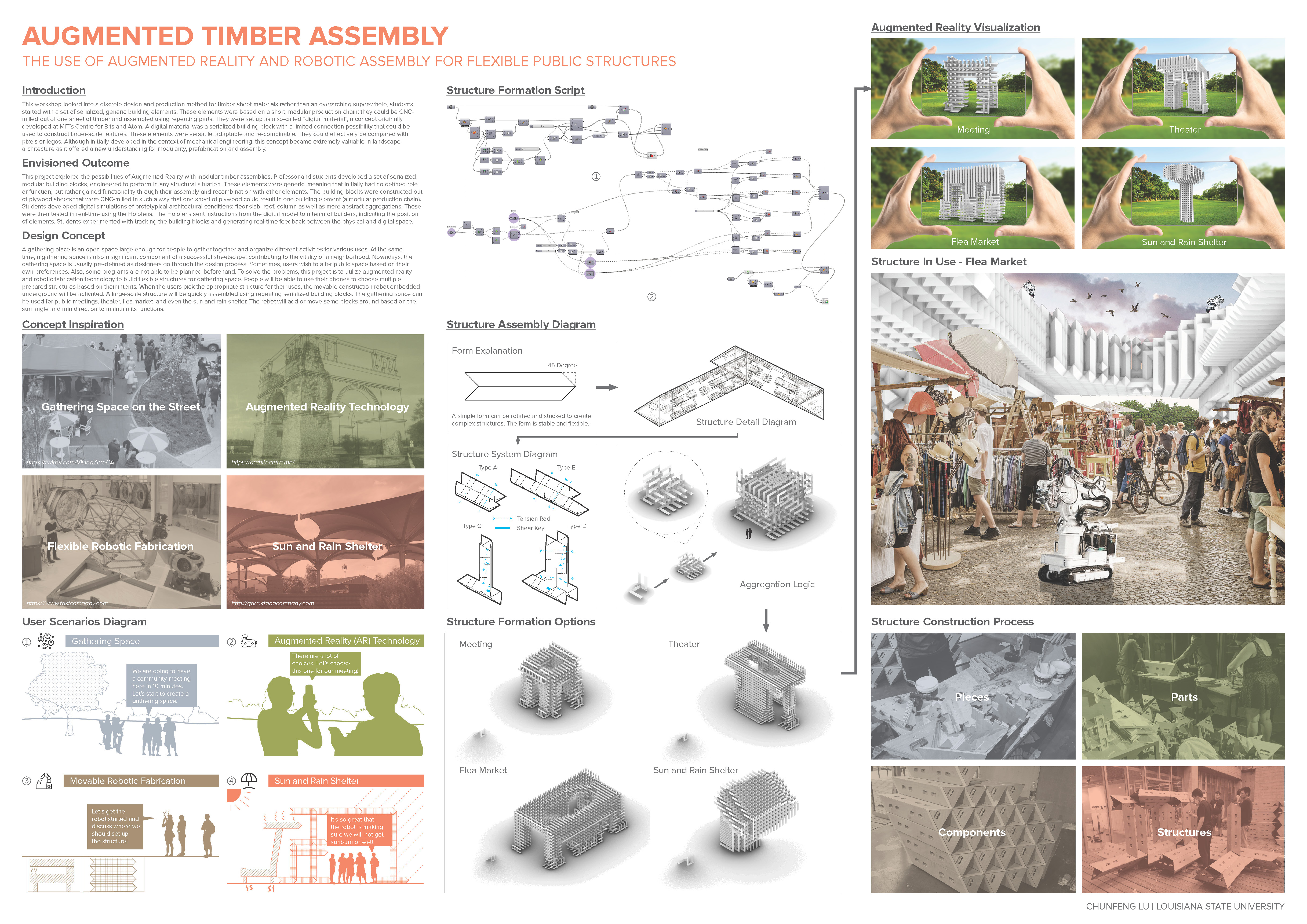
Abstract: ” A gathering place is an open space large enough for people to gather together and organize different activities for various uses. At the same time, a gathering space is also a significant component of a successful streetscape, contributing to the vitality of a neighborhood. Nowadays, the gathering space is usually pre-defined as designers go through the design process. Sometimes, users wish to alter public space based on their own preferences. Also, some programs are not able to be planned beforehand. To solve the problems, this project is to utilize augmented reality and robotic fabrication technology to build flexible structures for gathering space. People will be able to use their phones to choose multiple prepared structures based on their intents. When the users pick the appropriate structure for their uses, the movable construction robot embedded underground will be activated. A large-scale structure will be quickly assembled using repeating serialized building blocks. The gathering space can be used for public meetings, theater, flea market, and even the sun and rain shelter. The robot will add or move some blocks around based on the sun angle and rain direction to maintain its functions. “
Abstract: Honiara, capital of Solomon Islands, faces various climatic disasters which include coastal erosion, sea level rise, coastal flooding, flash floods and riverine flooding. The project focuses on the event of Riverine floodings in Honiara and studying the underlying causes including geography, infrastructure and population, data provided by Honiara city council. With the use of ArcGIS, the provided data was used in producing the mappings delineating the catchment areas, flood plains, buffer zones, high sloped terrains and high flood risk zones. Overlaying of these various data sets provided an analysis of the floodplains and which areas are suitable for checkpoints to reduce riverine flooding. The analysis was based on the speculative relationships between various aspects which determined the suitability of the areas.
Abstract: “This project explores the adaptive reuse and integration of wasted sites, with specific emphasis on quarries.
Quarries are a contested landscape for reuse as they have the potential to become public open spaces for communal enjoyment, or sites for municipal and industrial waste disposal. The former adding cultural value to an urban context, the latter perpetuating unsustainable practices that characterise the modern era. Quarry X in Midrand, South Africa is positioned within this tension.
Considering this, as well as the industrial sublime qualities of Quarry X, the project proposes a minimal landscape architectural intervention for the adaptive reuse of Quarry X.
The proposed design aims to reconcile the friction between modern-day exploits and cultural enrichment – creating a captivating destination for public use. “
Abstract: As there is a huge number of photos that were taken in the public parks uploaded on Flickr, the Flickr dataset with geolocation can provide a new perspective for us to understand the hotspot area, where people are more likely to gather in parks. During the pandemic of COVID-19, social distance becomes necessary and some parks are partly or entirely closed for public health. Studying the hotspot area in the parks can help figure out people’s preference in park spaces, which may provide reference and evidence for landscape planners and designers to think how to modified space and for park managers to think how to plan closure or limitation for the certain space for dealing the challenge of COVID-19. The study use R to mine and analyze Flickr data to visualize the distribution of visitors in Central Park in different seasons and time.
Abstract: The Hawker Centre is a social nexus point in Singaporean culture, bringing together family, friends and people of different cultural backgrounds to enjoy food and good company in an informal setting. The project aims to expand this notion to incorporate social programme, interweaving urban green and a plethora of leisure activities within a single active landscape. Thus establishing a new social heart of the otherwise anonymous new Punggol urban development.
By translating the movement of people into a multilevel topography, the project, in turn, creates a water channel network that seamlessly connects the site with the new Waterway park development. The channel system works not only as a visual guide, but also serves as a floodwater catchment body, filtering the water and creating a micro-climate within.
The topography folds out to enable covered programme with services that blend in and out of the green park-like landscape, blurring the boundary between inside and outside.
Abstract: The student project “Intercellular” proposes a future-oriented way of designing responsive landscapes through the understanding and integration of natural patterns as design driver. The zoning of the site is controlled by a cellular system. The pattern is developed by applying a voronoi algorithm and by manipulating the position and density of the points. The topography of this artificial island is automatically generated and influenced by environmental factors like rain, wind and sun direction. Through this method the runoff water is purified in responsive new water catchment areas, which as well interact as a mediator of different seawater levels. The urban design is a logic consequence of the computational model and allows change and adaption.

Abstract:
– 3D visualizations can aid public engagement by communicating spatial
and temporal implications of proposed designs to a diverse user group
– Visualization effectiveness is highly related to their perceived realism
– Adding sound to visualizations can result in a higher sense of perceived
realism, preference and biodiversity
– It is thought that experiencing virtual landscapes in via head mounted
display (HMD) is more realistic, however there are conflicting results in the literature
– Additionally few studies have evaluated the impact of multisensory
simulation using objective measures (e.g. heart rate, galvanic skin response (GSR))
– We used GSR and compare results to subjective perceptual measures to
assess their congruency
– We expected that perceived realism, preference, experienced
biodiversity and GSR would increase with sound and when using an HMD compared to viewing on screen
– Results confirm the expectations
Abstract: Water birds reflect the habitat integrity of a wetland. Birds tend to stay longer in areas that sustain food, shelter, and other life-support systems. In Candaba Swamp, migratory birds dwindle over the last ten years. Only 1,449 were recorded in 2018, the lowest since 2010 with 13,160 birds. This is critical because the swamp serves as a major refuge habitat during Siberian cold winds for many species of migratory and local birds. Land use change and water loss worsen the swamp’s diminishing habitat integrity. Moreover, difficulty in monitoring due to the wetland’s vastness and inaccessibility remains a challenge. However, satellite-derived information like Landsat provides a cheaper and easier method in studying the vegetation dynamics and seasonal water occurrence of wetlands.
This research attempts to improve the habitat integrity of Candaba Swamp by identifying key conservation and preservation areas in the bird sanctuary. By doing so, landscape architecture intervention and spatial analysis advance. Using Google Earth Engine and Landsat data, the vegetation dynamics and seasonal water occurrence were studied. Specifically, Normalized Difference Vegetation Index (NDVI) dataset from 2013-2019, and Global Surface Water (GSW) information from 1984-2015 were utilized to perform the task. A total of 38 potential habitat zones were explored by overlaying the existing habitat patches over the collected multi-spectral vegetation profile (NDVI) and seasonal water occurrence dataset (GSW). Analyses suggested the implementation of more strict preservation measures in the existing bird sanctuary (patch 5, 4, 3). The GSW dataset also revealed that patch 33,34,35, and 36 hold water resources that may serve as new nesting and breeding grounds for birds. However, these patches also record high water loss over the years. Lastly, a stronger observance of land use change particularly in lieu of agricultural farms and residential areas expansions were noted in patch 38, 29, 22, 20, 34, 36.
This study advances the convergence of satellite-derived information as cutting-edge tools in monitoring ecological functions. The process reveals the use of multi-spectral dataset in Google Earth Engine in informing new policies and improving ecological functions.
Abstract: “After Plastics: The Gardens of the Glacial Foreland” is a transitional landscape – from glacial to post-glacial – where microplastics play a critical role in the development of a new plant growth pattern, strategically augmented through the intervention of the landscape architect. The production of the garden is in continuous evolution as the landscape is perpetually reformed through a new compositional stratum of the post-Anthropocene material: plastics. Its operation relies on a metabolic process that transforms and transfers novel material conditions between an interconnected web of mycelium, slime mold, ancient lichens awakened from their dormant state, and a wide range of Allium species. The project questions the potential emergence of microplastic particles in the most remote, pristine places on Earth over the next two centuries and the imminent implications on landscape systems and their formation through parallels between geological and biological time scales. Organized in a series of laboratories – Landscape Performance, Material Taxonomy, Material Ecology and Garden Prototyping – “After Plastics” engages in a telescopic lens from the emerging micro scalar ecologies of biological structure and chemical compounds to the larger scale of networks and flows that generate new material ecologies.
Abstract: Data infrastructure is fundamental despite its short presence of several decades in the contemporary society and it is vulnerable both climatically and politically. As we are seeing with federal climate data, it cannot be legally deleted but access to it can be limited and obscured. Hence, we question typical relationship between users, data creation, and data storage and use this as an opportunity to rethink the design of data centers and sensored research landscapes in coastal areas threatened by sea level rise.
Sentient Landscapes leverages research universities strength as a land-owning entity and their existing interest in sensored ecological research to propose that Boston universities such as Harvard, MIT, and Tufts partner to build a new technological corridor that is dependent upon the landscape it is embedded within. We aspire to design a new data system that completes two major functions: first, abandoned, inland quarries are reclaimed to be used as a new data center campus, to create a suitable environment for new economy. Second,
universities will sensor the coastal landscapes and subsidize the move of coastal populations away from vulnerable flooding sites. This landscape will fill the gaps in our knowledge about novel coastal ecosystems and how they will move relative to the unknown speed of climate change by producing long-term datasets.

Abstract: American tech companies powerfully shape our physical spaces, societal values and habits. The ingenuity behind Amazon’s logistics network is its ability to use information to respond to and also shape our consumer landscape with maximum operational efficiency.
In the near future city, we, as designers, redistribute Amazon’s wealth to increase the social, ecological and economic equity within our urban environments. The project investigates how designers can shape the consumer landscape at multiple scales of intervention, by combating decreased ecological diversity and decreased social interaction and reprieving in the current Amazon dominated consumer landscape.
Abstract: The master thesis presents a data-driven framework to explore the role of dynamic time and direction patterns in the area of Finnish Lapland in order to improve decision-making in complex urban planning and design tasks. The Arctic Ocean Railway project is chosen as a case study.
In an era marked by dramatic environmental, political and societal changes, the Arctic region becomes more global and complex. In order to cope with the increasing complexity of such dynamic urban and regional challenges, Systems Thinking, dynamic patterns, modelling and use of simulation are researched to open up novel ways for complex regional planning methods.
The project attempts to address the necessity to handle the increasing complexity of changing built and natural environment by presenting a dynamic, evidence-based planning and decision support tool called CityScope Lapland. The main goal of CityScope Lapland is to use digital technologies to incorporate dynamic variables in urban spatial analysis and methodology; secondly, to improve the accessibility of the decision-making process for non-experts through a tangible user interface, and third, to help users evaluate their decisions by creating feedback through real-time visualization of urban simulation results.
This is achieved by designing an agent-based model and using different representation and abstraction features for different dynamic data packages. The project is integrated within the GAMA simulation platform and embedded in the MIT CityScope framework – a medium for both, analyzing agent’s behavioural patterns and displaying them to the stakeholders.
Abstract: This project explores the use of sensors and actuators on two peatland sites in Quebec, Canada in relation to a virtual exhibition/office site for the purposes of peatland restoration and environmental activism. Peatlands store 200% more CO2 than all of Earths forests while covering 10% only the area. Site conditions can vary greatly within 1-m elevation of a peatland, and sensors provide a higher resolution analysis of topography, water table height, light levels, and vegetation, which informs design interventions over time. Planting and cutting of vegetation, topography manipulation, and controlled flooding can be prescribed by the landscape architect remotely and carried out by drones and autonomous rovers. The virtual (data) landscape of the site is communicated to the public on the site via an app, and remotely using a multi-sensory exhibition where data is spatialized. Continuous monitoring expands project scope and duration, reframing engagement with the landscape(s) over time and space.
Abstract: This project is a parametric 20 meter by 20 meter replicable park designed using management strategies over a time period of 18 years. The project generates an abstract language for a deep study of biotic variables, including coppicing and pollarding strategies for slow-growing olive and fast-growing poplar species, temperature and precipitation for the site in Arles, France represented in a Gaussian diagram over a period of 30 years, and the effects of shading out and overcrowding plants through growth and competition. The project also investigates abiotic factors, such as possible irrigation system timing and how changing the size of the system impacts its ability to function overall. The resulting proposal is a pollarded park with an 18 year old cycle that has a clear ecological logic, as well as a clear emphasis on stewardship and a strong spatial design. The final proposal is represented through a traditional hand-drawing to communicate to a broader audience the possibilities of parametric design that works closely with ecological cycles, which naturally rely simplification and abstraction to communicate. This re-translation of digital design work is a necessary secondary step to engage the communities where projects will live. The project shows how an abstract language can be devised and used to translate complex information before being represented as a spatial experience that is also regenerative to soil and plant life though careful management practices.
Abstract: This project uses open-source 81 distinct NOAA Tree Ring Data sets from Russia, the United States and Canada to propose an ecosystem-based management system that takes advantage of the similar forest composition across the boreal forest. Climate change threatens to contract the area of the boreal forest, pushing the appropriate climatic conditions northward at a rate that trees are unable to migrate to match. The findings of this research project suggest that climatic shifts are happening at relatively equivalent rates across nations – and instead of defining the territory used to combat climate change in the boreal forest by national borders, we should use ecosystem-based management to redraw a cartography of the forest, and share resources across international borders to manage these lands. The project also creates a simple procedure in R for designers who are unfamiliar with the software.